
Muscle Cars Antique Cars Racing Cars Exotic Cars Classic Cars
Car Things To Do
Scenic Drives
For those that would like to plan a road trip anywhere in the USA, we would like to suggest some scenic and fun driving routes I have cruised and assure you they are beautiful. Many are fun twisty and challenging drives while others are miles of fantastic scenery. You pick the ones that appeal to you and enjoy every turn in the road and person you meet. Enjoy!
Sedona, AZ

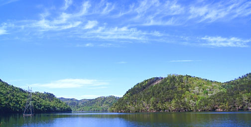
"Tail of the Dragon" is in a remote section of the Great Smokey Mountains beginning in Deals Gap, NC at the junction of the Tennessee state line along route 129 going from Robbinsville, NC into TN. With 318 curves in 11 miles, it is considered by many to be the number one motorcycle and sports car road in the USA. There are no facilities or access roads along the 11 miles so be prepared. There are photographers stationed along the Dragon to capture you and your car - smile! While in this area you take the time to drive the nearby Moonshiner 28 and Cherohala routes.


"Moonshiner 28" is a fantastic scenic route to be enjoyed with your special car and partner. Stretching from US 129 at Tail of the Dragon in Deals Gap, Moonshiner 28 winds its way southeastward 103 miles through Franklin and Highlands North Carolina before turning southward into Georgia and South Carolina, ending at the sleepy town of Walhalla. This route, as the name implies, was once a running route for moonshiners but today serves as a great scenic drive with many turns, twisties, sweepers and beautiful mountain scenery plus some secluded lakes and waterfalls. There is even a camping area along this route if you want to spend a night in the woods!


"Cherohala Skyway" begins in Robbinsville, NC and winds up the mountain to a height of over 5,000 feet for 15 miles in North Carolina and then descends 21 miles into the forests of Tennessee. This lovely drive crisscrosses through the Cherokee and Nantahala National Forests, thus the name “Chero…hala”. The natural beauty and scenic overlooks are breathtaking, with a number of opportunities to stop and enjoy the views. There are no facilities or services along the route other than a couple of restrooms, so be prepared and make sure you have enough gas. A picnic lunch and afternoon nap would be a delightful way to add to the pleasures of this scenic drive. This highway has the record of being North Carolina’s most expensive, carrying a price tag of $100,000,000 and taking 34 years to construct.

"The Blue Ridge Parkway" is a beautiful ribbon of road that weaves along the Appalachian Highlands for 469 miles with old farmsteads, mountain meadows, scenic overlooks plus hiking trails, picnic areas and campsites. The Parkway was originally built to connect Shenandoah National Park to the Great Smoky Mountains National Park and was part of Franklin D. Roosevelt’s New Deal efforts beginning in 1935 to provide jobs for the unemployed during the Great Depression. This beautiful piece of history is an outstanding landmark and well-maintained great driving route, marking its 75th anniversary in 2010. A cruise along the Blue Ridge Parkway is an experience unlike any other: a slow-paced and relaxing drive revealing stunning long-range vistas and close-up views of the rugged mountains and pastoral landscapes of the Appalachian Highlands. The scenes are exemplary during spring bloom or fall foliage. Caution: - parts of the Parkway are remote, there are closures during the winter and car speed limits are strictly controlled.


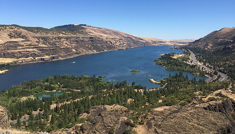
"Columbia River Gorge" is the largest national scenic area in the United States. The gorge and canyon carve a line between the states of Oregon and Washington via routes I-84, U.S. Route 30 and Washington State Route 14 with railroad tracks on both sides. Don't miss the nearby snowcaps of Mt. Hood and Multnomah Falls located in the Gorge between Corbett and Dodson, Oregon.


"17-Mile Drive" and the Del Monte Forest" are recognized as one of the most scenic drives in the world. The famous coastal landmark runs through Pacific Grove to Pebble Beach, encompassing the beautiful and dramatic Pacific coastline to the majestic Del Monte Forest. A drive will take you through Pebble Beach while touching Monterey and Carmel by-the-Sea. You will be guided by 21 marked points of interest and view golf at its best with spectacular settings provided by the Pebble Beach Golf Links and other neighboring courses. You will also enjoy wind swept cypress trees, spectacular homes and Mother Nature at her best provided by the Pacific Ocean.


"Miami Beach to Key West" is a spectacular scenic drive making you think you are in the islands but you are in the USA. After you get past the hustle and bustle of the city of Miami you will enter a majestic travel lane, along US route 1, for three hours of Caribbean-blue seas surrounded by sunshine and sites unlike anywhere else in the USA. This trip can be done in a few hours but take the time and make it a few days or week and stop to go snorkeling at John Pennekamp’s State Park, fish at Islamorada, drive the Seven Mile Bridge (near Marathon, FL) or just hang-out at numerous other watering holes and eateries along the way. When you arrive in Key West, put on your flip-flops, grab a bike and enjoy the many sites, sounds, tastes and history of this famous city.


"Pacific Coast Highway" winds down California’s coastal mid-section providing spectacular views of the Pacific Ocean and rugged coast line for 123 miles. Get on highway 1 beginning in Monterey and continue south with highlights such as Carmel-by-the-Sea, Point Lobos State Reserve and Big Sur and ending at Morro Bay. Enjoy the Pacific Ocean, renowned vistas and beach pull-offs with scenic overlooks.


"The Natchez Trace Parkway" is a 444 mile National Parkway running from Natchez, Mississippi to Nashville, Tennessee. It roughly follows the Old Natchez Trace, a historic corridor used by the “Kaintucks”, an American Indian tribe, European settlers, soldiers, etc. While it is a fabulous scenic drive it can also serve as a vacation destination offering hiking, biking, horseback riding and camping. Should you venture this route try a meal at The Loveless Café, Southern cooking dating from 1951, that is located at the entrance/exit of the Trace in Nashville.


"Route 66" covers 2400 miles, beginning in Chicago continuing through the Midwest and ending in Los Angeles. It is also known as the Will Rogers Highway or Main Street of America. Rte. 66 was established in 1926 and made popular on the TV show and song by the same name airing from 1960 – 1964. The highway was officially removed from the United States Highway System in 1985 but portions of the route have been designated, by some states, as part of the National Scenic Byway of the name “Historic Route 66”, and thus returning to maps. The name recognition, charm and beauty of this famous road bring travelers from all over world to experience America and our great historic Route 66. Check it out you might be tempted to do the entire stretch just as those young men did on TV in the early 60’s in their Corvette.
"Jacinto Reyes Scenic Byway" should be considered while in Southern California and specifically the LA area. This byway is a couple hours North of LA and is part of State Route 33 that stretches for 38 miles, winding through the Topatopa Mountains and the Los Padres National Forest. This route is a short distance from the city and provides a remote mix of high and low speed corners and spectacular mountain scenery. Perhaps you take this route on your way to Paso Robles for some winery tours.
"Lake Superior, North Shore Drive" covers 142 miles along highway 61 from Canal Park in Duluth, Minnesota to Canada, sweeping the Lake Superior shoreline which is the largest fresh water lake in the world. This trip can easily be done in a day or longer as you enjoy the spectacular scenery, especially in the fall. There are eight state parks plus the Superior National Forest and don’t miss the Gooseberry River and Falls and the Split Rock lighthouse.